History
During the 1970’s, the Post Office Coastal Radio Station in Cullercoats, United Kingdom began broadcasting weather forecasts and warnings for the North Sea and the English Channel using radio teletype and it became fully operational in 1983. It was adopted by other countries and scaled up to the international system named NAVTEX. The International Marine Organization incorporated the system into the regulations. It is now part of the GMDSS (Global Maritime Distress and Safety System) and mandatory for all SOLAS ships. NAVTEX is used to automatically transmit maritime safety messages, weather forecasts, and urgent warnings to ships up to approximately 400 nautical miles from the coast.
Folly is a non-SOLAS ship and has an independent NAVTEX receiver with display that is switching between 518 kHz band and 490 kHz twice daily. The information on stations, weather forecasts and broadcast schedule for certain areas may help to select the correct station and switching time(s).
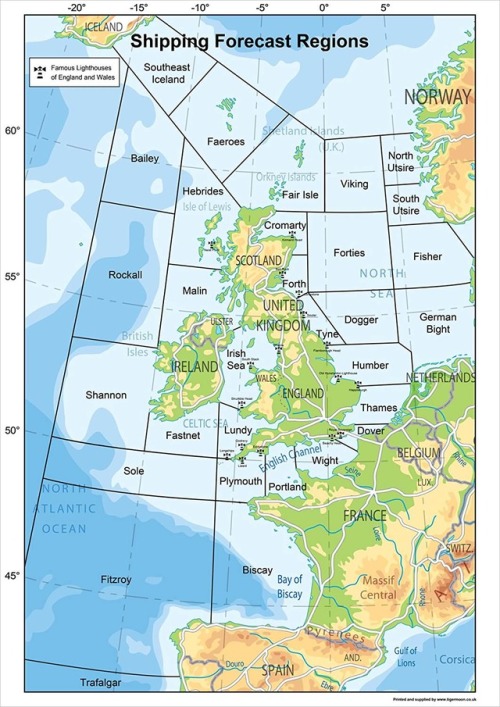
Stations and districts around the Northsea

NAVTEX broadcasts around the Northsea at 518 kHz
W=weather forecast; times in UTC
| Station | ID | Area | 00:00-04:00 | 04:00-08:00 | 08:00-12:00 | 12:00-16:00 | 16:00-20:00 | 20:00-00:00 |
|---|---|---|---|---|---|---|---|---|
| Cullercoats | G | Fair Isle, Viking, Cromarty, Forties, Forth, Tyne, Dogger, Humber, Thames | 01:00 (W) | 05:00 | 09:00 (W) | 13:00 | 17:00 | 21:00 (W) |
| Pinneberg | S | German Bight | 03:00 (W) | 07:00 (W) | 11:00 (W) | 15:00 (W) | 19:00 (W) | 23:00 (W) |
| Dutch Coastguard | P | Dogger, Humber, Thames, German Bight | 02:30 (W) | 06:30 | 10:30 | 14:30 (W) | 18:30 | 22:30 |
| Oostende | T | Coasts of Belgium | 03:10 | 07:10 (W) | 11:10 | 15:10 | 19:10 (W) | 23:10 |
| Oostende | V | English Channel – English side | 03:30 (W) | 07:30 (W) | 11:30 (W) | 15:30 (W) | 19:30 (W) | 23:30 (W) |
| Niton | E | Thames, Dover, Wight, Portland, Fastnet, Lundy, Sole, Plymouth, Fitzroy, Biscay | 00:40 | 04:40 | 08:40 (W) | 12:40 | 16:40 | 20:40 (W) |
| Niton | K | English Channel – French side | 01:40 (W) | 05:40 | 09:40 | 13:40 (W) | 17:40 | 21:40 |
NAVTEX broadcasts around the Northsea at 490 kHz
| Station (Language) | ID | Area | 00:00-04:00 UTC | 04:00-08:00 UTC | 08:00-12:00 UTC | 12:00-16:00 UTC | 16:00-20:00 UTC | 20:00-00:00 UTC |
|---|---|---|---|---|---|---|---|---|
| Cullercoats | U | Fair Isle, Viking, Cromarty, Forties, Forth, Tyne, Dogger, Humber, Thames | 03:20 | 07:20 (W) | 11:20 (W) | 15:20 | 19:20 (W) | 23:20 (W) |
| Pinneberg | L | German North Sea Coasts | 01:50 | 05:50 (W) | 09:50 | 13:50 | 17:50 | 21:50 (W) |
| Oostende (Dutch) |
B | Coasts of Belgium | 00:10 (W) | 04:10 (W) | 08:10 (W) | 12:10 (W) | 16:10 (W) | 20:10 (W) |
| Niton | I | Southern coasts and Channel | 01:20 (W) | 05:20 (W) | 09:20 | 13:20 (W) | 17:20 (W) | 21:20 |
| Niton (French) |
T | English Channel – French side | 03:10 | 07:10 (W) | 11:10 | 15:10 | 19:10 (W) | 23:10 |
The British Maritime and Coastguard Agency has published an set of excellent Marine Guidance Notes on Maritime Safety.
Frequent used abbreviation in NAVTEX messages
🌦️ Weather & Meteorology
| GALE | Gale (Force 7 or higher) |
| STORM | Severe storm |
| FOG | Fog |
| ICE | Ice (sea or drift ice) |
| WX | Weather |
| WIND | Wind information |
| VIS | Visibility |
| TEMP | Temperature |
⚠️ Hazards & Warnings
| NAVWARN | Navigational warning |
| HYDROLANT | Hydrographic warning (Atlantic Ocean) |
| HYDROPAC | Hydrographic warning (Pacific Ocean) |
| CABLE | Submarine cable (damaged or under work) |
| MINE | Mine danger |
| DERELICT | Abandoned vessel or object |
| OBSTN | Obstruction |
| DRILL | Exercise (military or platform-related) |
🚢 Navigation & Maritime
| LIGHT | Lighthouse or light structure |
| BUOY | Buoy |
| LT EX | Light extinguished (not working) |
| AID TO NAV | Aid to navigation |
| CH | Channel (navigable waterway) |
| SHOAL | Shallow area |
📍 Positions & Communication
| POSN | Position |
| LAT | Latitude |
| LON | Longitude |
| VHF | Very High Frequency |
| MF | Medium Frequency |
🧾 Message Structure
| MSG | Message |
| BROADCAST | Broadcast |
| NR | Number of the message |
| UTC | Coordinated Universal Time |